|
search place name
|
||
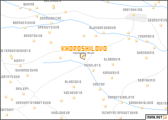
Khoroshilovo (Orlovskaya Oblast', Russia)Khoroshilovo is a town in the Orlovskaya Oblast' region of Russia. An overview map of the region around Khoroshilovo is displayed below.
regional and 3d topo map of Khoroshilovo, Russia ::
Khoroshilovo airports ::
The nearest airport is BZK - Bryansk, located 104.3 km west of Khoroshilovo.
Nearby towns ::
Novaya Zhizn' (0.5km north) //
Vesëloye (2.6km south east) //
Bobraki (3.3km west) //
Lebëdka (5.5km north) //
Karelkino (5.7km north) //
Almazovo (6.1km south) //
Slobodka (4.0km east) //
Kondrëvo (5.5km south east) //
Vostok (6.8km south) //
Aleksandrovka (6.6km north east) //
Vorob'yëvka (6.0km north west) //
Kochevaya (8.5km south) //
Novo-Fedotovo (9.1km south) //
Spesivtsevo (7.8km north west) //
Gorodishche (9.3km north west) //
[all distances 'as the bird flies' and approximate]  Places with similar names to Khoroshilovo, Russia ::
// Khoroshilov (RU)
// Khoroshilovo (RU)
// Khoroshilovo (RU)
// Khoroshilovo (RU)
// Khoroshilovo (RU)
Disclaimer :: Information on this page comes without warranty of any kind |
||
|
Where is Khoroshilovo? Elevation and coordinates ::
Latitude (lat): 52°52'42"N Longitude (lon): 35°37'41"E
Elevation (approx.): 214m (map arrows pan, magnifying glasses zoom) |
||
|
Visiting Khoroshilovo? Hotel/Accommodation ::
Book a hotel in Khoroshilovo Travel Guide ::
Buy a travel guide for Russia rental cars ::
car rental offers GPS waypoint ::
download a GPX waypoint (PoI) of Khoroshilovo for your GPS receiver
|
||