|
search place name
|
||
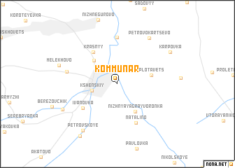
Kommunar (Kurskaya Oblast', Russia)Kommunar is a town in the Kurskaya Oblast' region of Russia. An overview map of the region around Kommunar is displayed below.
regional and 3d topo map of Kommunar, Russia ::
Kommunar airports ::
The nearest airport is VOZ - Voronezh Chertovitskoye, located 102.1 km east of Kommunar.
Nearby towns ::
Kshenskiy (2.7km west) //
Volzhanets (4.4km north west) //
Nizhnyaya Grayvoronka (4.7km south) //
Plotavets (3.6km east) //
Krasnyy (5.6km north west) //
Ivanovka (5.1km south west) //
Natal'ino (6.4km south) //
Anninskoye (7.4km north) //
Goloshchapovka (5.3km west) //
Petrovo-Kartsevo (7.9km north east) //
Petrovskoye (8.2km south west) //
Oktyabr'skoye (6.8km south west) //
Karpovka (7.2km north east) //
Krasnaya Dolina (9.1km south west) //
[all distances 'as the bird flies' and approximate] 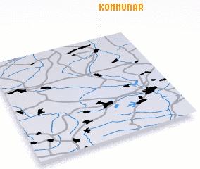 Places with similar names to Kommunar, Russia ::
// Caimanera (CU)
// Caimanera (CU)
// Kawm an Nūr (EG)
// Kawm an Nūr (EG)
// Komunari (BG)
// Kommunar (UA)
// Ga-Monare (ZA)
// Kamennyy Yar (RU)
// Kommunar (RU)
// Kommunar (RU)
Disclaimer :: Information on this page comes without warranty of any kind |
||
|
Where is Kommunar? Elevation and coordinates ::
Latitude (lat): 51°51'0"N Longitude (lon): 37°45'0"E
Elevation (approx.): 188m (map arrows pan, magnifying glasses zoom) |
||
|
Visiting Kommunar? Hotel/Accommodation ::
Book a hotel in Kommunar Travel Guide ::
Buy a travel guide for Russia rental cars ::
car rental offers GPS waypoint ::
download a GPX waypoint (PoI) of Kommunar for your GPS receiver
|
||