|
search place name
|
||
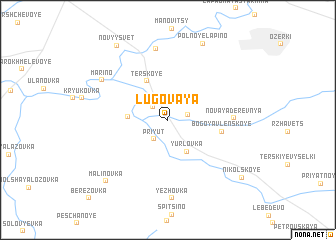
Lugovaya (Tambovskaya Oblast', Russia)Lugovaya is a town in the Tambovskaya Oblast' region of Russia. An overview map of the region around Lugovaya is displayed below.
regional and 3d topo map of Lugovaya, Russia ::
Lugovaya airports ::
The nearest airport is VOZ - Voronezh Chertovitskoye, located 142.4 km south west of Lugovaya.
Nearby towns ::
Litunovka (1.8km north west) //
Turovka (1.5km north east) //
Priyut (2.3km south west) //
Yurlovka (3.8km south) //
Krasnaya Sloboda (2.7km west) //
Terskoye (4.6km north) //
Bogoyavlenskoye (3.9km east) //
Novaya Derevnya (4.5km east) //
Borshchëvskiye Vyselki (8.0km north) //
Mar'ino (6.3km north west) //
Yezhovka (8.7km south) //
Pol'noye Lapino (8.8km north) //
Malinovka (8.0km south west) //
Novyy Svet (9.0km north west) //
Nikol'skoye (8.1km south east) //
Berëzovka (10.2km south west) //
[all distances 'as the bird flies' and approximate]  Places with similar names to Lugovaya, Russia ::
Disclaimer :: Information on this page comes without warranty of any kind |
||
|
Where is Lugovaya? Elevation and coordinates ::
Latitude (lat): 52°44'42"N Longitude (lon): 40°39'45"E
Elevation (approx.): 129m (map arrows pan, magnifying glasses zoom) |
||
|
Visiting Lugovaya? Hotel/Accommodation ::
Book a hotel in Lugovaya Travel Guide ::
Buy a travel guide for Russia rental cars ::
car rental offers GPS waypoint ::
download a GPX waypoint (PoI) of Lugovaya for your GPS receiver
|
||