|
search place name
|
||
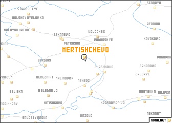
Mertishchevo (Smolenskaya Oblast', Russia)Mertishchevo is a town in the Smolenskaya Oblast' region of Russia. An overview map of the region around Mertishchevo is displayed below.
regional and 3d topo map of Mertishchevo, Russia ::
Mertishchevo airports ::
The nearest airport is BZK - Bryansk, located 176.2 km south of Mertishchevo.
Nearby towns ::
Lushchikovo (3.1km south east) //
Petrikino (3.3km north west) //
Zhashkovo (3.3km south east) //
Nemerz' (5.3km south) //
Podmosh'ye (4.3km north east) //
Volochëk (5.6km north) //
Malinovka (5.4km south west) //
Gorodok (6.6km south) //
Sekarëvo (5.6km north west) //
Torzhok (7.1km south) //
Piskari (6.0km north west) //
Barsuki (5.2km west) //
Berezniki (6.8km south west) //
Isslednevo (8.8km south west) //
[all distances 'as the bird flies' and approximate]  Places with similar names to Mertishchevo, Russia :: Disclaimer :: Information on this page comes without warranty of any kind |
||
|
Where is Mertishchevo? Elevation and coordinates ::
Latitude (lat): 54°45'26"N Longitude (lon): 33°34'46"E
Elevation (approx.): 212m (map arrows pan, magnifying glasses zoom) |
||
|
Visiting Mertishchevo? Hotel/Accommodation ::
Book a hotel in Mertishchevo Travel Guide ::
Buy a travel guide for Russia rental cars ::
car rental offers GPS waypoint ::
download a GPX waypoint (PoI) of Mertishchevo for your GPS receiver
|
||