|
search place name
|
||
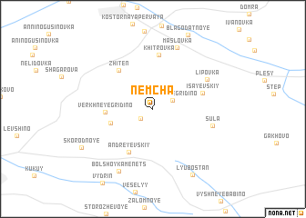
Nemcha (Kurskaya Oblast', Russia)Nemcha is a town in the Kurskaya Oblast' region of Russia. An overview map of the region around Nemcha is displayed below.
regional and 3d topo map of Nemcha, Russia ::
Nemcha airports ::
The nearest airport is BZK - Bryansk, located 227.1 km north west of Nemcha.
Nearby towns ::
Izvekovo (1.5km south west) //
Nizhneye Gridino (1.8km north east) //
Vtoraya Yekaterinovka (3.7km south west) //
Verkhneye Gridino (3.7km west) //
Andreyevskiy (5.6km south) //
Zhiten' (5.4km north west) //
Isayevskiy (4.3km north east) //
Khitrovka (6.7km north) //
Lipovka (5.5km north east) //
Sula (5.0km south east) //
Maslovka (7.8km north) //
Bol'shoy Kamenets (8.1km south) //
Lyubostan' (8.7km south) //
Skorodnoye (7.3km south west) //
[all distances 'as the bird flies' and approximate]  Places with similar names to Nemcha, Russia ::
// Namchaw (MM)
// Namhsio (MM)
// Namsio (MM)
// Neumeichow (DE)
// Namišiai (LT)
// Numšiai (LT)
// Nioumachoua (KM)
// Nambashi (IN)
// Namchi (IN)
// Nimach (IN)
Disclaimer :: Information on this page comes without warranty of any kind |
||
|
Where is Nemcha? Elevation and coordinates ::
Latitude (lat): 51°23'55"N Longitude (lon): 35°41'49"E
Elevation (approx.): 186m (map arrows pan, magnifying glasses zoom) |
||
|
Visiting Nemcha? Hotel/Accommodation ::
Book a hotel in Nemcha Travel Guide ::
Buy a travel guide for Russia rental cars ::
car rental offers GPS waypoint ::
download a GPX waypoint (PoI) of Nemcha for your GPS receiver
|
||