|
search place name
|
||
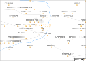
Nikanovo (Moskovskaya Oblast', Russia)Nikanovo is a town in the Moskovskaya Oblast' region of Russia. An overview map of the region around Nikanovo is displayed below.
regional and 3d topo map of Nikanovo, Russia ::
Nearby towns ::
Anokhino (0.0km north) //
Staryy Spas (2.1km south west) //
Malaya Il'inka (2.1km north east) //
Kupliyam (2.6km south east) //
Pochinki (3.9km north) //
Krekhtino (4.3km north west) //
Butovo (5.6km north) //
Zhabka (5.7km north) //
Bol'shaya Il'inka (3.7km north west) //
Denisovo (4.9km north west) //
Kolionovo (7.4km north) //
Novoye Yerokhino (4.2km west) //
Staroye Yerokhino (4.6km north west) //
Antipino (6.4km north east) //
Alfërovo (7.7km south) //
Klyupanovo (5.6km south east) //
Yanino (5.6km south west) //
Yurinskoye (5.6km south west) //
Annenki (8.1km south west) //
Rakhmanovo (8.5km north west) //
[all distances 'as the bird flies' and approximate]  Places with similar names to Nikanovo, Russia ::
Disclaimer :: Information on this page comes without warranty of any kind |
||
|
Where is Nikanovo? Elevation and coordinates ::
Latitude (lat): 55°14'0"N Longitude (lon): 39°27'0"E
Elevation (approx.): 112m (map arrows pan, magnifying glasses zoom) |
||
|
Visiting Nikanovo? Hotel/Accommodation ::
Book a hotel in Nikanovo Travel Guide ::
Buy a travel guide for Russia rental cars ::
car rental offers GPS waypoint ::
download a GPX waypoint (PoI) of Nikanovo for your GPS receiver
|
||