|
search place name
|
||
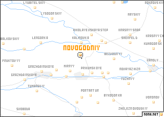
Novogodniy (Stavropol'skiy Kray, Russia)Novogodniy is a town in the Stavropol'skiy Kray region of Russia. An overview map of the region around Novogodniy is displayed below.
regional and 3d topo map of Novogodniy, Russia ::
Novogodniy airports ::
The nearest airport is MRV - Mineralnye Vody Mineralnyye Vody, located 16.5 km east of Novogodniy.
Other airports nearby include STW - Stavropol Shpakovskoye (111.7 km north west), Nearby towns ::
Neftekachka (2.4km north) //
(( Kalinovka )) (3.6km north) //
Orbel'yanovka (3.6km south) //
Mirnyy (3.5km south west) //
Prikumskoye (3.7km south east) //
Uspenovka (4.8km south west) //
Yeruslanovka (4.6km south east) //
Nikolayevskaya Step' (5.6km north) //
Ul'yanovka (5.2km north east) //
Krasnoye Pole (5.0km south west) //
Dunayevka (5.5km south east) //
(( Krasnaya Dolina )) (5.3km north east) //
Dolina (5.5km south east) //
(( Bezvodnyy )) (5.2km east) //
Sunzha (6.3km south west) //
Port-Artur (8.6km south) //
Verblyudogorka (8.9km south) //
[all distances 'as the bird flies' and approximate] 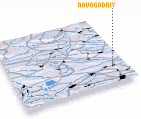 Places with similar names to Novogodniy, Russia :: Disclaimer :: Information on this page comes without warranty of any kind |
||
|
Where is Novogodniy? Elevation and coordinates ::
Latitude (lat): 44°16'3"N Longitude (lon): 42°53'3"E
Elevation (approx.): 388m (map arrows pan, magnifying glasses zoom) |
||
|
Visiting Novogodniy? Hotel/Accommodation ::
Book a hotel in Novogodniy Travel Guide ::
Buy a travel guide for Russia rental cars ::
car rental offers GPS waypoint ::
download a GPX waypoint (PoI) of Novogodniy for your GPS receiver
|
||