|
search place name
|
||
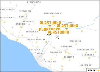
Plastunka (Krasnodarskiy Kray, Russia)Plastunka is a town in the Krasnodarskiy Kray region of Russia. An overview map of the region around Plastunka is displayed below.
regional and 3d topo map of Plastunka, Russia ::
Plastunka airports ::
The nearest airport is AER - Sochi, located 28.9 km south east of Plastunka.
Other airports nearby include KRR - Krasnodar Pashkovskiy (158.9 km north), Nearby towns ::
Plastunka (2.4km north) //
Baranovka (2.4km south west) //
Chetvërtaya Rota (2.6km north) //
Razbityy Kotel (2.8km north) //
Plastunka (2.6km south east) //
Nizhneye Orekhovo (4.4km north) //
Verkhne Yurt (4.4km south) //
Vasil'yevka (3.6km west) //
Russkaya Mamayka (4.4km south west) //
Novaya Zarya (5.1km south west) //
Sergey-Pole (4.7km west) //
Novaginka (6.4km south) //
Plastunka (4.9km east) //
Verkhne Orekhovo (7.4km north) //
Varvarovka (5.8km north west) //
Bogushevka (7.4km south) //
Verkhovskoye (6.7km south east) //
Izmaylovka (6.8km south east) //
Novyy Sochi (7.4km south west) //
Kepsha (7.3km south east) //
Sochi (8.1km south) //
Razdol'noye (8.8km south) //
Azhek (6.9km north east) //
Sobolevka (8.8km south) //
Baranovka (7.2km north west) //
Progress (8.3km south east) //
Krayevsko-Armyanskoye (9.1km south east) //
[all distances 'as the bird flies' and approximate]  Places with similar names to Plastunka, Russia ::
Disclaimer :: Information on this page comes without warranty of any kind |
||
|
Where is Plastunka? Elevation and coordinates ::
Latitude (lat): 43°40'9"N Longitude (lon): 39°45'48"E
Elevation (approx.): 71m (map arrows pan, magnifying glasses zoom) |
||
|
Visiting Plastunka? Hotel/Accommodation ::
Book a hotel in Plastunka Travel Guide ::
Buy a travel guide for Russia rental cars ::
car rental offers GPS waypoint ::
download a GPX waypoint (PoI) of Plastunka for your GPS receiver
|
||