|
search place name
|
||
Pyatiletka (Udmurtiya, Russia)Pyatiletka is a town in the Udmurtiya region of Russia. An overview map of the region around Pyatiletka is displayed below.
regional and 3d topo map of Pyatiletka, Russia ::
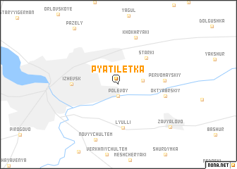
Nearby towns ::
Trudpchela (1.9km south) //
Polevoy (1.9km south) //
Chemoshur (2.2km east) //
Starki (4.9km north east) //
Lyulli (6.9km south) //
Pervomayskiy (4.0km east) //
Izhevsk (4.1km west) //
Oktyabr'skiy (4.5km south east) //
Khokhryaki (7.6km north) //
Novyy Chul'tem (8.9km south) //
Zav'yalovo (8.1km south east) //
[all distances 'as the bird flies' and approximate] 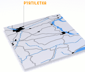 Places with similar names to Pyatiletka, Russia ::
// Pyatiletka (UZ)
// Pyatiletka (RU)
// Pyatiletka (RU)
// Pyatiletka (RU)
// Pyatiletka (RU)
// Pyatiletka (RU)
// Pyatiletka (RU)
// Pyatiletka (RU)
// Pyatiletka (RU)
// Pyatiletka (RU)
Disclaimer :: Information on this page comes without warranty of any kind |
||
|
Where is Pyatiletka? Elevation and coordinates ::
Latitude (lat): 56°51'0"N Longitude (lon): 53°18'0"E
Elevation (approx.): 158m (map arrows pan, magnifying glasses zoom) |
||
|
Visiting Pyatiletka? Hotel/Accommodation ::
Book a hotel in Pyatiletka Travel Guide ::
Buy a travel guide for Russia rental cars ::
car rental offers GPS waypoint ::
download a GPX waypoint (PoI) of Pyatiletka for your GPS receiver
|
||