|
search place name
|
||
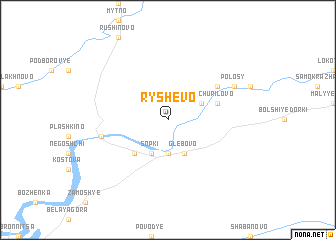
Ryshevo (Novgorodskaya Oblast', Russia)Ryshevo is a town in the Novgorodskaya Oblast' region of Russia. An overview map of the region around Ryshevo is displayed below.
regional and 3d topo map of Ryshevo, Russia ::
Ryshevo airports ::
The nearest airport is LED - St. Petersburg Pulkovo, located 161.5 km north west of Ryshevo.
Nearby towns ::
Priluki (3.7km south) //
Baranikha (2.7km north east) //
Glebovo (3.8km south) //
Sopki (3.8km south) //
Koshkino (4.2km south west) //
Churilovo (3.4km north east) //
Zhabnitsy (4.7km north east) //
Novoye Selo (4.3km south west) //
Polosy (5.4km north east) //
[all distances 'as the bird flies' and approximate]  Places with similar names to Ryshevo, Russia ::
// Riacho Feio I (BR)
// Riacho Feio II (BR)
// Richview (US)
// Reishof (DE)
// Röshof (DE)
// Hrushovo (UA)
// Rochivo (MX)
// Rachiv (TJ)
// Roche à Feu (HT)
// Rochov (CZ)
Disclaimer :: Information on this page comes without warranty of any kind |
||
|
Where is Ryshevo? Elevation and coordinates ::
Latitude (lat): 58°35'0"N Longitude (lon): 31°48'0"E
Elevation (approx.): 42m (map arrows pan, magnifying glasses zoom) |
||
|
Visiting Ryshevo? Hotel/Accommodation ::
Book a hotel in Ryshevo Travel Guide ::
Buy a travel guide for Russia rental cars ::
car rental offers GPS waypoint ::
download a GPX waypoint (PoI) of Ryshevo for your GPS receiver
|
||