|
search place name
|
||
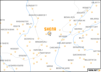
Shëna (Chechnya, Russia)Shëna is a town in the Chechnya region of Russia. An overview map of the region around Shëna is displayed below.
regional and 3d topo map of Shëna, Russia ::
Shëna airports ::
The nearest airport is MCX - Makhachkala Uytash, located 118.7 km east of Shëna.
Nearby towns ::
Malyye Shuani (1.4km north west) //
Isay-Yurt (2.8km east) //
Gordali-Yurt (3.8km south) //
Turty-Khutor (3.3km north east) //
Masi-Khutor (3.4km south east) //
Bas-Gordali (4.1km south west) //
Khashki-Mokhk (3.5km west) //
Sayasan (3.8km east) //
Chachanki (5.6km south) //
Gansolchu (6.0km north) //
Kerla-Engenoy (5.4km south east) //
Yalkhoy-Mokhk (5.4km north west) //
Alleroy (5.6km east) //
Tsentoroy (7.5km south) //
(( Kurchali )) (7.1km south west) //
Gezenchu (6.1km west) //
Akhkinchu-Borzoy (7.4km north west) //
Davletbi-Khutor (6.8km north east) //
Bel'ty (6.6km north west) //
Verkhniye Kurchali (7.9km south west) //
Sredniye Kurchali (7.9km south west) //
Beshil'-Irzu (7.8km north east) //
Nizhniye Kurchali (7.7km south west) //
Borze (9.1km south) //
Sherdi-Mokhk (7.3km south west) //
Koshka-Ara (9.5km south west) //
[all distances 'as the bird flies' and approximate]  Places with similar names to Shëna, Russia ::
Disclaimer :: Information on this page comes without warranty of any kind |
||
|
Where is Shëna? Elevation and coordinates ::
Latitude (lat): 43°4'23"N Longitude (lon): 46°14'23"E
Elevation (approx.): 595m (map arrows pan, magnifying glasses zoom) |
||
|
Visiting Shëna? Hotel/Accommodation ::
Book a hotel in Shëna Travel Guide ::
Buy a travel guide for Russia rental cars ::
car rental offers GPS waypoint ::
download a GPX waypoint (PoI) of Shëna for your GPS receiver
|
||