|
search place name
|
||
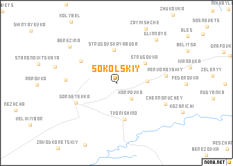
Sokol'skiy (Bryanskaya Oblast', Russia)Sokol'skiy is a town in the Bryanskaya Oblast' region of Russia. An overview map of the region around Sokol'skiy is displayed below.
regional and 3d topo map of Sokol'skiy, Russia ::
Sokol'skiy airports ::
The nearest airport is GME - Gomel, located 85.5 km south west of Sokol'skiy.
Nearby towns ::
Karpovka (2.8km south east) //
Danilovka (3.0km east) //
Strugovskaya Buda (5.3km north) //
Strugovka (4.2km north east) //
Tvorishino (5.8km south) //
Krasnyy Borets (5.0km north west) //
Gordeyevka (5.1km south west) //
Pervomayskiy (4.9km east) //
Rudnya-Vorob'yevka (5.0km west) //
Cherno-Ruchey (5.7km south east) //
Glinnoye (8.0km north east) //
Berezina (7.4km north west) //
Zaymishche (9.2km north) //
[all distances 'as the bird flies' and approximate]  Places with similar names to Sokol'skiy, Russia ::
// Schleuskau (DE)
// Schleußig (DE)
// Schloßheck (DE)
// Schloßig (DE)
// Schölisch (DE)
// Skalskie (PL)
// Skulsk (PL)
// Sokołowsko (PL)
// Wysokie Laski (PL)
// Šakališkė (LT)
Disclaimer :: Information on this page comes without warranty of any kind |
||
|
Where is Sokol'skiy? Elevation and coordinates ::
Latitude (lat): 52°59'19"N Longitude (lon): 32°1'45"E
Elevation (approx.): 167m (map arrows pan, magnifying glasses zoom) |
||
|
Visiting Sokol'skiy? Hotel/Accommodation ::
Book a hotel in Sokol'skiy Travel Guide ::
Buy a travel guide for Russia rental cars ::
car rental offers GPS waypoint ::
download a GPX waypoint (PoI) of Sokol'skiy for your GPS receiver
|
||