|
search place name
|
||
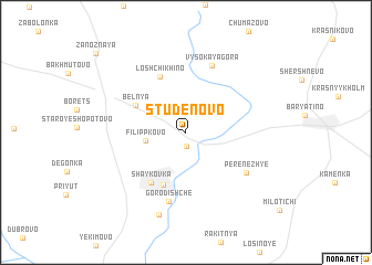
Studënovo (Kaluzhskaya Oblast', Russia)Studënovo is a town in the Kaluzhskaya Oblast' region of Russia. An overview map of the region around Studënovo is displayed below.
regional and 3d topo map of Studënovo, Russia ::
Studënovo airports ::
The nearest airport is BZK - Bryansk, located 121.4 km south of Studënovo.
Nearby towns ::
Sil'kovichi (1.4km south) //
Filippkovo (2.5km west) //
Bel'nya (4.0km north west) //
Anisovo Gorodishche (5.5km south) //
Shaykovka (5.5km south) //
Loshchikhino (5.9km north) //
Gorodishche (7.0km south) //
Vysokaya Gora (6.9km north) //
Perenezh'ye (5.4km south east) //
Vypolzovo (8.5km south) //
[all distances 'as the bird flies' and approximate]  Places with similar names to Studënovo, Russia ::
// Studënova (RU)
// Studënovo (RU)
// Studënovo (RU)
// Štětínov (CZ)
// Ciudad Nueva (DO)
// Cidade Nova (BR)
Disclaimer :: Information on this page comes without warranty of any kind |
||
|
Where is Studënovo? Elevation and coordinates ::
Latitude (lat): 54°17'45"N Longitude (lon): 34°24'55"E
Elevation (approx.): 220m (map arrows pan, magnifying glasses zoom) |
||
|
Visiting Studënovo? Hotel/Accommodation ::
Book a hotel in Studënovo Travel Guide ::
Buy a travel guide for Russia rental cars ::
car rental offers GPS waypoint ::
download a GPX waypoint (PoI) of Studënovo for your GPS receiver
|
||