|
search place name
|
||
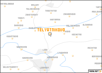
Telyatnikovo (Kurskaya Oblast', Russia)Telyatnikovo is a town in the Kurskaya Oblast' region of Russia. An overview map of the region around Telyatnikovo is displayed below.
regional and 3d topo map of Telyatnikovo, Russia ::
Telyatnikovo airports ::
The nearest airport is BZK - Bryansk, located 180.5 km north west of Telyatnikovo.
Nearby towns ::
Maritsa (2.8km north west) //
Ivanchikovo (3.2km east) //
Khryapnik (5.4km north) //
L'gov (5.9km south) //
Nikolayevka (4.2km north west) //
Lyushinka (7.3km south) //
Komarovka (8.5km south) //
Trostnitsa (8.6km north) //
Polyachkovo (5.9km north east) //
Zakharkovo (8.5km north east) //
Zavetenskiy (8.4km north west) //
Gorodensk (8.7km south east) //
Sherëkino (10.2km south west) //
[all distances 'as the bird flies' and approximate] 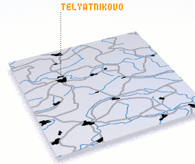 Places with similar names to Telyatnikovo, Russia ::
// Telyatnikova (RU)
// Telyatnikovo (RU)
// Telyatnikovo (RU)
// Telyatnikovo (RU)
// Telyatnikovo (RU)
// Telyatnikova (BY)
Disclaimer :: Information on this page comes without warranty of any kind |
||
|
Where is Telyatnikovo? Elevation and coordinates ::
Latitude (lat): 51°44'36"N Longitude (lon): 35°17'54"E
Elevation (approx.): 168m (map arrows pan, magnifying glasses zoom) |
||
|
Visiting Telyatnikovo? Hotel/Accommodation ::
Book a hotel in Telyatnikovo Travel Guide ::
Buy a travel guide for Russia rental cars ::
car rental offers GPS waypoint ::
download a GPX waypoint (PoI) of Telyatnikovo for your GPS receiver
|
||