|
search place name
|
||
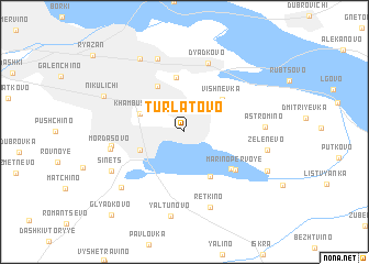
Turlatovo (Ryazanskaya Oblast', Russia)Turlatovo is a town in the Ryazanskaya Oblast' region of Russia. An overview map of the region around Turlatovo is displayed below.
regional and 3d topo map of Turlatovo, Russia ::
Nearby towns ::
Khambushëvo (3.2km north west) //
Kachevo Vtoroye (3.2km south west) //
Vishnëvka (4.0km north east) //
Polenskoye (4.7km south) //
Sokolovka (4.9km north) //
Sheremet'yevo-Pesochnya (5.6km north) //
Kamenets (4.6km south east) //
Mar'ino Pervoye (4.9km south east) //
Dyad'kovo (7.1km north) //
Kachevo Pervoye (4.5km west) //
Mordasovo (4.7km west) //
Cherizovo-Pesochnya (7.5km north) //
Retkino (7.8km south) //
Astromino (4.8km east) //
Sinets (5.9km south west) //
Zatish'ye (6.7km south west) //
Yaltunovo (8.6km south) //
Zelenëvo (5.2km east) //
Dashkovo-Pesochnya (7.8km north) //
Nikulichi (6.0km north west) //
Aleksandrovo (6.3km south east) //
Glyadkovo (9.5km south west) //
[all distances 'as the bird flies' and approximate]  Places with similar names to Turlatovo, Russia :: Disclaimer :: Information on this page comes without warranty of any kind |
||
|
Where is Turlatovo? Elevation and coordinates ::
Latitude (lat): 54°33'1"N Longitude (lon): 39°49'27"E
Elevation (approx.): 162m (map arrows pan, magnifying glasses zoom) |
||
|
Visiting Turlatovo? Hotel/Accommodation ::
Book a hotel in Turlatovo Travel Guide ::
Buy a travel guide for Russia rental cars ::
car rental offers GPS waypoint ::
download a GPX waypoint (PoI) of Turlatovo for your GPS receiver
|
||