|
search place name
|
||
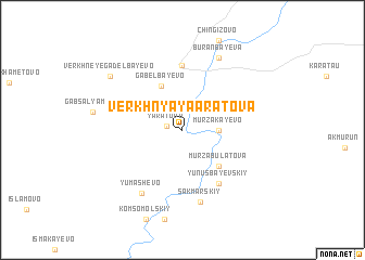
Verkhnyaya Aratova (Bashkortostan, Russia)Verkhnyaya Aratova is a town in the Bashkortostan region of Russia. An overview map of the region around Verkhnyaya Aratova is displayed below.
regional and 3d topo map of Verkhnyaya Aratova, Russia ::
Verkhnyaya Aratova airports ::
The nearest airport is MQF - Magnetiogorsk Magnitogorsk, located 105.6 km north east of Verkhnyaya Aratova.
Nearby towns ::
Yaratovo (1.0km west) //
Murzakayevo (2.3km east) //
Gabel'bayevo (4.7km north) //
Murzabulatova (4.3km south east) //
Itkulovo Pervoye (6.6km north) //
Yunusbayevskiy (6.0km south) //
Sakmarskiy (7.5km south) //
Yumashevo (7.0km south) //
Staraya Kinzebulatova (7.7km north) //
Buranbayeva (7.7km north) //
Verkhneye Gadel'bayevo (7.2km north west) //
[all distances 'as the bird flies' and approximate] 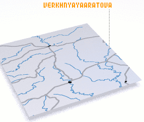 Places with similar names to Verkhnyaya Aratova, Russia :: Disclaimer :: Information on this page comes without warranty of any kind |
||
|
Where is Verkhnyaya Aratova? Elevation and coordinates ::
Latitude (lat): 52°34'0"N Longitude (lon): 57°59'0"E
Elevation (approx.): 464m (map arrows pan, magnifying glasses zoom) |
||
|
Visiting Verkhnyaya Aratova? Hotel/Accommodation ::
Book a hotel in Verkhnyaya Aratova Travel Guide ::
Buy a travel guide for Russia rental cars ::
car rental offers GPS waypoint ::
download a GPX waypoint (PoI) of Verkhnyaya Aratova for your GPS receiver
|
||