|
search place name
|
||
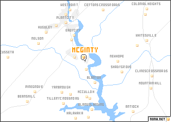
McGinty (Alabama, United States - USA)McGinty is a town in the Alabama region of United States - USA. An overview map of the region around McGinty is displayed below.
regional and 3d topo map of McGinty, United States - USA ::
McGinty airports ::
The nearest airport is LSF - Fort Benning Lawson Aaf, located 51.1 km south of McGinty.
Other airports nearby include ANB - Anniston Metro (111.5 km north west), ATL - Hartsfield Jackson Atlanta Intl (116.8 km north east), MXF - Montgomery Maxwell Afb (122.0 km west), MGE - Marietta Dobbins Arb (Atlanta Nas) (139.4 km north east), Nearby towns ::
Osanippa (1.8km south) //
Glass (2.2km north west) //
Blanton (5.1km south) //
Valley (5.3km north west) //
Eady City (6.0km north) //
New Hope (5.9km east) //
McCulloh (7.9km south) //
Beulah (7.9km south) //
Jester (8.3km south) //
Shady Grove (7.1km east) //
Yarbrough (8.1km south west) //
Plant City (9.2km north west) //
Little Shawmut (9.4km north west) //
Huguley (9.6km north west) //
[all distances 'as the bird flies' and approximate]  Places with similar names to McGinty, United States - USA ::
// McGinty (US)
Disclaimer :: Information on this page comes without warranty of any kind |
||
|
Where is McGinty? Elevation and coordinates ::
Latitude (lat): 32°46'38"N Longitude (lon): 85°9'8"W
Elevation (approx.): 211m (map arrows pan, magnifying glasses zoom) |
||
|
Visiting McGinty? Hotel/Accommodation ::
Book a hotel in McGinty Travel Guide ::
rental cars ::
car rental offers GPS waypoint ::
download a GPX waypoint (PoI) of McGinty for your GPS receiver
|
||