|
search place name
|
||
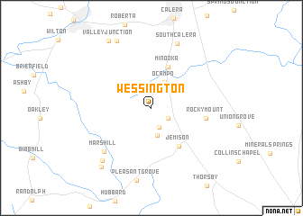
Wessington (Alabama, United States - USA)Wessington is a town in the Alabama region of United States - USA. An overview map of the region around Wessington is displayed below.
regional and 3d topo map of Wessington, United States - USA ::
Wessington airports ::
The nearest airport is BHM - Birmingham Intl, located 62.2 km north of Wessington.
Other airports nearby include MXF - Montgomery Maxwell Afb (78.8 km south east), ANB - Anniston Metro (107.5 km north east), CBM - Colombus Columbus Afb (170.7 km north west), NMM - Meridian Nas (173.9 km west), Nearby towns ::
Oak Grove (2.2km south east) //
Kalona (2.6km south) //
Center Hill (3.4km south) //
Ocampo (3.5km north) //
Minooka (5.4km north) //
Jemison (5.6km south east) //
Rocky Mount (5.8km east) //
Mars Hill (7.3km south west) //
South Calera (8.4km north) //
Bessie (8.3km south west) //
Dry Valley (9.1km north west) //
Poseys Crossroads (9.0km south west) //
Valley Junction (9.4km north west) //
[all distances 'as the bird flies' and approximate] 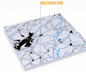 Places with similar names to Wessington, United States - USA ::
// Wessington (US)
// Wissington (GB)
Disclaimer :: Information on this page comes without warranty of any kind |
||
|
Where is Wessington? Elevation and coordinates ::
Latitude (lat): 33°0'9"N Longitude (lon): 86°46'40"W
Elevation (approx.): 196m (map arrows pan, magnifying glasses zoom) |
||
|
Visiting Wessington? Hotel/Accommodation ::
Book a hotel in Wessington Travel Guide ::
rental cars ::
car rental offers GPS waypoint ::
download a GPX waypoint (PoI) of Wessington for your GPS receiver
|
||