|
search place name
|
||
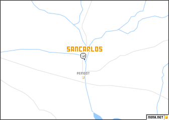
San Carlos (Arizona, United States - USA)San Carlos is a town in the Arizona region of United States - USA. An overview map of the region around San Carlos is displayed below.
regional and 3d topo map of San Carlos, United States - USA ::
San Carlos airports ::
The nearest airport is DMA - Tucson Davis Monthan Afb, located 136.8 km south of San Carlos.
Other airports nearby include TUS - Tucson Intl (143.8 km south), PHX - Phoenix Sky Harbor Intl (145.4 km west), LUF - Phoenix Luke Afb (180.7 km west), FHU - Fort Huachuca Sierra Vista Muni Libby Aaf (195.1 km south), Nearby towns ::
Peridot (3.9km south) //
[all distances 'as the bird flies' and approximate]  Places with similar names to San Carlos, United States - USA ::
// San Carlos (US)
// San Carlos (US)
// San Carlos (PA)
// San Carlos (PA)
// Singréllos (GR)
// Cinco Reales (CU)
// San Carlos (CU)
// San Carlos (CU)
// San Carlos (CU)
// San Carlos (CU)
Disclaimer :: Information on this page comes without warranty of any kind |
||
|
Where is San Carlos? Elevation and coordinates ::
Latitude (lat): 33°20'43"N Longitude (lon): 110°27'9"W
Elevation (approx.): 809m (map arrows pan, magnifying glasses zoom) |
||
|
Visiting San Carlos? Hotel/Accommodation ::
Book a hotel in San Carlos Travel Guide ::
rental cars ::
car rental offers GPS waypoint ::
download a GPX waypoint (PoI) of San Carlos for your GPS receiver
|
||