|
search place name
|
||
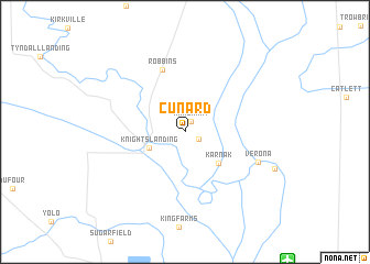
Cunard (California, United States - USA)Cunard is a town in the California region of United States - USA. An overview map of the region around Cunard is displayed below.
regional and 3d topo map of Cunard, United States - USA ::
Cunard airports ::
The nearest airport is SMF - Sacramento Intl, located 15.5 km south east of Cunard.
Other airports nearby include MCC - Sacramento Mc Clellan Afld (29.6 km south east), SAC - Sacramento Executive (37.4 km south east), BAB - Marysville Beale Afb (41.7 km north east), RIU - Rancho Murieta (62.3 km south east), Nearby towns ::
 Places with similar names to Cunard, United States - USA ::
Disclaimer :: Information on this page comes without warranty of any kind |
||
|
Where is Cunard? Elevation and coordinates ::
Latitude (lat): 38°48'50"N Longitude (lon): 121°41'5"W
Elevation (approx.): 4m (map arrows pan, magnifying glasses zoom) |
||
|
Visiting Cunard? Hotel/Accommodation ::
Book a hotel in Cunard Travel Guide ::
rental cars ::
car rental offers GPS waypoint ::
download a GPX waypoint (PoI) of Cunard for your GPS receiver
|
||