|
search place name
|
||
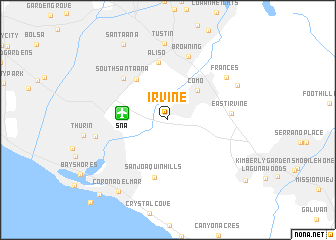
Irvine (California, United States - USA)Irvine is a town in the California region of United States - USA. An overview map of the region around Irvine is displayed below.
regional and 3d topo map of Irvine, United States - USA ::
nearby GPS traces from timatio ::
Irvine airports ::
The nearest airport is SNA - Santa Ana John Wayne Arpt Orange Co, located 4.3 km west of Irvine.
Other airports nearby include LGB - Long Beach (34.7 km north west), RAL - Riverside Muni (46.9 km north east), ONT - Ontario Intl (47.5 km north east), HHR - Jack Northrop Fld Hawthorne Muni (55.2 km north west), Nearby towns ::
Como (4.3km north east) //
Dyer (5.4km north west) //
Aliso (6.5km north) //
San Joaquin Hills (6.5km south) //
South Santa Ana (6.3km north west) //
East Irvine (5.9km east) //
Browning (7.4km north) //
Frances (7.2km north east) //
Santa Ana Heights (7.0km west) //
Tustin (8.5km north) //
Kathryn (7.5km north east) //
Corona del Mar (9.2km south west) //
Santa Ana (9.4km north west) //
Aliso Viejo (9.9km south east) //
Balboa Island (10.5km south west) //
[all distances 'as the bird flies' and approximate]  Places with similar names to Irvine, United States - USA ::
Disclaimer :: Information on this page comes without warranty of any kind |
||
|
Where is Irvine? Elevation and coordinates ::
Latitude (lat): 33°40'10"N Longitude (lon): 117°49'20"W
Elevation (approx.): 22m (map arrows pan, magnifying glasses zoom) |
||
|
Visiting Irvine? Hotel/Accommodation ::
Book a hotel in Irvine Travel Guide ::
rental cars ::
car rental offers GPS waypoint ::
download a GPX waypoint (PoI) of Irvine for your GPS receiver
|
||