|
search place name
|
||
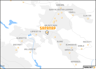
Saranap (California, United States - USA)Saranap is a town in the California region of United States - USA. An overview map of the region around Saranap is displayed below.
regional and 3d topo map of Saranap, United States - USA ::
Saranap airports ::
The nearest airport is OAK - Metropolitan Oakland Intl, located 22.2 km south west of Saranap.
Other airports nearby include SFO - San Francisco Intl (39.6 km south west), SUU - Fairfield Travis Afb (43.9 km north), NUQ - Mountain View Moffett Federal Afld (52.1 km south), SJC - Norman Y Mineta San Jose Intl (59.4 km south), Nearby towns ::
Sacanap (0.9km north) //
Walnut Creek (2.6km north) //
Walnut Heights (2.4km south east) //
Lafayette (3.7km west) //
Waldon (4.9km north) //
Sparkle (5.1km north) //
Las Juntas (5.6km north) //
Alamo (5.5km south east) //
Bancroft (6.0km north east) //
Hookston (6.6km north) //
Meinert (7.8km north east) //
Four Corners (8.6km north) //
Valle Vista (8.8km south west) //
Sunny Acres Trailer Park (9.5km north east) //
Danville (9.7km south east) //
[all distances 'as the bird flies' and approximate] 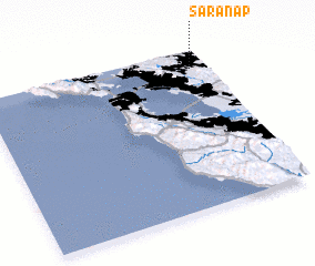
Disclaimer :: Information on this page comes without warranty of any kind |
||
|
Where is Saranap? Elevation and coordinates ::
Latitude (lat): 37°53'6"N Longitude (lon): 122°4'30"W
Elevation (approx.): 58m (map arrows pan, magnifying glasses zoom) |
||
|
Visiting Saranap? Hotel/Accommodation ::
Book a hotel in Saranap Travel Guide ::
rental cars ::
car rental offers GPS waypoint ::
download a GPX waypoint (PoI) of Saranap for your GPS receiver
|
||