|
search place name
|
||
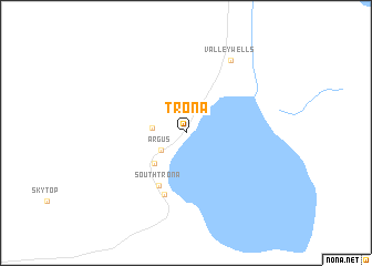
Trona (California, United States - USA)Trona is a town in the California region of United States - USA. An overview map of the region around Trona is displayed below.
regional and 3d topo map of Trona, United States - USA ::
Trona airports ::
The nearest airport is EDW - Edwards Afb, located 105.9 km south west of Trona.
Other airports nearby include PMD - Palmdale Rgnl Usaf Plt 42 (141.5 km south west), BFL - Bakersfield Meadows Fld (157.0 km west), ONT - Ontario Intl (190.5 km south), BUR - Burbank Bob Hope (195.3 km south west), Nearby towns ::
Argus (2.7km south west) //
Searles Valley (2.9km west) //
Borosolvay (4.0km south west) //
South Trona (5.7km south west) //
Westend (6.5km south) //
Valley Wells (8.2km north east) //
[all distances 'as the bird flies' and approximate] 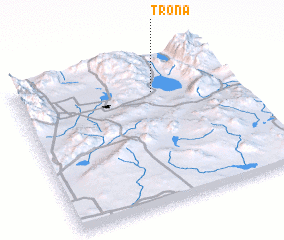 Places with similar names to Trona, United States - USA ::
Disclaimer :: Information on this page comes without warranty of any kind |
||
|
Where is Trona? Elevation and coordinates ::
Latitude (lat): 35°45'46"N Longitude (lon): 117°22'19"W
Elevation (approx.): 504m (map arrows pan, magnifying glasses zoom) |
||
|
Visiting Trona? Hotel/Accommodation ::
Book a hotel in Trona Travel Guide ::
rental cars ::
car rental offers GPS waypoint ::
download a GPX waypoint (PoI) of Trona for your GPS receiver
|
||