|
search place name
|
||
West Anaheim (California, United States - USA)West Anaheim is a town in the California region of United States - USA. An overview map of the region around West Anaheim is displayed below.
regional and 3d topo map of West Anaheim, United States - USA ::

nearby GPS traces from timatio ::
West Anaheim airports ::
The nearest airport is SNA - Santa Ana John Wayne Arpt Orange Co, located 18.7 km south of West Anaheim.
Other airports nearby include LGB - Long Beach (19.5 km west), HHR - Jack Northrop Fld Hawthorne Muni (37.8 km west), ONT - Ontario Intl (40.1 km north east), LAX - Los Angeles Intl (44.8 km west), Nearby towns ::
Brookhurst (2.0km north west) //
Anaheim (2.6km east) //
Fullerton (4.5km north) //
Micaflores (4.5km south east) //
South Anaheim (4.6km south east) //
Clair (4.8km south west) //
Almond (4.9km north west) //
Garden Grove (6.5km south) //
Del Prado Mobile Park Club (6.4km south) //
Stanton (5.7km south west) //
West Anaheim Junction (5.9km south east) //
Los Alamitos Junction (6.0km south west) //
Buena Park (6.5km north west) //
Sunny Hills (7.7km north) //
Hansen (6.5km west) //
La Jolla (6.7km north east) //
Colonia Manzanilla (8.0km south) //
Westminster (10.1km south west) //
[all distances 'as the bird flies' and approximate] 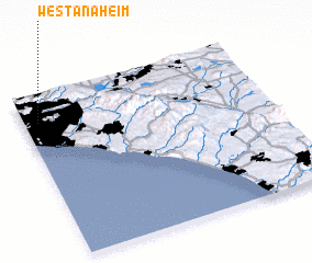 Places with similar names to West Anaheim, United States - USA :: Disclaimer :: Information on this page comes without warranty of any kind |
||
|
Where is West Anaheim? Elevation and coordinates ::
Latitude (lat): 33°49'56"N Longitude (lon): 117°56'30"W
Elevation (approx.): 40m (map arrows pan, magnifying glasses zoom) |
||
|
Visiting West Anaheim? Hotel/Accommodation ::
Book a hotel in West Anaheim Travel Guide ::
rental cars ::
car rental offers GPS waypoint ::
download a GPX waypoint (PoI) of West Anaheim for your GPS receiver
|
||