|
search place name
|
||
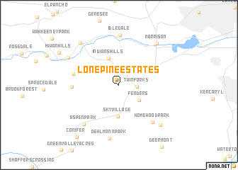
Lone Pine Estates (Colorado, United States - USA)Lone Pine Estates is a town in the Colorado region of United States - USA. An overview map of the region around Lone Pine Estates is displayed below.
regional and 3d topo map of Lone Pine Estates, United States - USA ::
Lone Pine Estates airports ::
The nearest airport is BKF - Buckley Afb, located 43.9 km east of Lone Pine Estates.
Other airports nearby include DEN - Denver Intl (57.2 km north east), COS - City Of Colorado Springs Muni (99.4 km south east), PUB - Pueblo Memorial Pueblo Mem (158.8 km south east), CYS - Cheyenne Rgnl Jerry Olson Fld (177.2 km north), Nearby towns ::
Indian Hills (2.5km north) //
Twin Forks (2.2km east) //
Fenders (3.4km south east) //
Indians Hills (4.4km north) //
Sky Village (4.9km south) //
Stanley Park (4.8km north west) //
Herzman Mesa (5.8km west) //
Marshdale (5.7km west) //
Homewood Park (7.1km south east) //
Idledale (7.9km north) //
Aspen Park (7.5km south west) //
Oehlmann Park (8.5km south) //
Morrison (8.0km north east) //
Kittredge (8.1km north west) //
Phillipsburg (8.0km south east) //
Evergreen (7.5km north west) //
Conifer (9.7km south west) //
[all distances 'as the bird flies' and approximate] 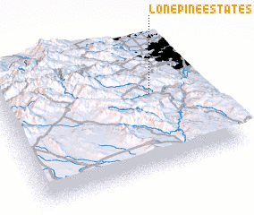 Places with similar names to Lone Pine Estates, United States - USA :: Disclaimer :: Information on this page comes without warranty of any kind |
||
|
Where is Lone Pine Estates? Elevation and coordinates ::
Latitude (lat): 39°35'42"N Longitude (lon): 105°14'41"W
Elevation (approx.): 2240m (map arrows pan, magnifying glasses zoom) |
||
|
Visiting Lone Pine Estates? Hotel/Accommodation ::
Book a hotel in Lone Pine Estates Travel Guide ::
rental cars ::
car rental offers GPS waypoint ::
download a GPX waypoint (PoI) of Lone Pine Estates for your GPS receiver
|
||