|
search place name
|
||
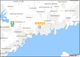
Mianus (Connecticut, United States - USA)Mianus is a town in the Connecticut region of United States - USA. An overview map of the region around Mianus is displayed below.
regional and 3d topo map of Mianus, United States - USA ::
Mianus airports ::
The nearest airport is HPN - White Plains Westchester Co, located 10.1 km west of Mianus.
Other airports nearby include LGA - New York La Guardia (37.9 km south west), BDR - Stratford Igor I Sikorsky Mem (41.3 km east), TEB - Teterboro (45.0 km south west), JFK - New York John F Kennedy Intl (47.6 km south), Nearby towns ::
Cos Cob (1.4km south west) //
Riverside (1.6km south east) //
North Mianus (1.8km north east) //
North Mianus (2.5km north) //
Palmers Hill (3.0km north east) //
Old Greenwich (3.2km south east) //
Greenwich (3.7km south west) //
Ridgeway (3.9km north east) //
Dolphin Cove (4.1km south east) //
Northfield (4.6km north east) //
Stamford (4.5km east) //
Belle Haven (5.2km south west) //
South End (4.6km east) //
Roxbury (5.7km north east) //
Rock Ridge (4.7km west) //
Pine Hill (5.4km north west) //
Riverbank (6.8km north) //
Glenbrook (5.9km north east) //
Glenville (5.8km west) //
Shippan Point (5.9km east) //
Belltown (6.4km north east) //
Pemberwick (6.2km west) //
Turn of River (7.5km north east) //
Byram (6.9km south west) //
Springdale (7.4km north east) //
Stanwich (8.7km north) //
Hunting Ridge (9.0km north) //
Port Chester (7.8km south west) //
Newfield (8.6km north east) //
[all distances 'as the bird flies' and approximate]  Places with similar names to Mianus, United States - USA ::
Disclaimer :: Information on this page comes without warranty of any kind |
||
|
Where is Mianus? Elevation and coordinates ::
Latitude (lat): 41°2'38"N Longitude (lon): 73°35'30"W
Elevation (approx.): 20m (map arrows pan, magnifying glasses zoom) |
||
|
Visiting Mianus? Hotel/Accommodation ::
Book a hotel in Mianus Travel Guide ::
rental cars ::
car rental offers GPS waypoint ::
download a GPX waypoint (PoI) of Mianus for your GPS receiver
|
||