|
search place name
|
||
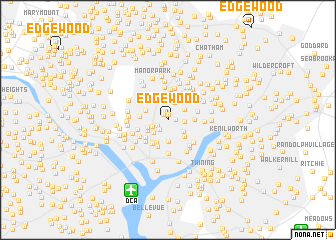
Edgewood (District of Columbia, United States - USA)Edgewood is a town in the District of Columbia region of United States - USA. An overview map of the region around Edgewood is displayed below.
regional and 3d topo map of Edgewood, United States - USA ::
Edgewood airports ::
The nearest airport is DCA - Ronald Reagan Washington Natl, located 8.4 km south of Edgewood.
Other airports nearby include ADW - Camp Springs Andrews Afb (Washington Dc Naf) (17.0 km south east), IAD - Washington Dulles Intl (39.5 km west), BWI - Baltimore Washington Intl (40.2 km north east), NHK - Patuxent River Nas (87.3 km south east), Nearby towns ::
Metropolis View (0.6km north) //
The Cloisters (0.7km north west) //
Edgewood Terrace (0.7km east) //
Park Place (1.0km north west) //
Bloomingdale (1.1km south west) //
Eckington (1.3km south west) //
Brentwood Village (1.4km east) //
LeDroit Park (1.5km south west) //
University Heights (2.0km north) //
Truxton Circle (1.9km south west) //
Brookland (1.8km north east) //
Ivy City (1.9km south east) //
Varnum (2.3km north) //
Stanton Park (2.3km south) //
Westminster (2.0km south west) //
Shaw (2.2km south west) //
Trinidad (2.3km south east) //
Park View (2.3km north west) //
East Central (2.7km south) //
Langdon (2.3km east) //
Washington City (2.9km south west) //
Mount Vernon Square (2.8km south west) //
East End (3.1km south) //
Judiciary Square (3.0km south west) //
Columbia Heights (2.5km west) //
Michigan Park (3.2km north east) //
Woodridge (2.7km east) //
North Michigan Park (3.0km north east) //
Chinatown (3.1km south west) //
[all distances 'as the bird flies' and approximate] 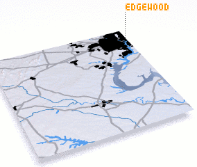 Places with similar names to Edgewood, United States - USA ::
Disclaimer :: Information on this page comes without warranty of any kind |
||
|
Where is Edgewood? Elevation and coordinates ::
Latitude (lat): 38°55'21"N Longitude (lon): 77°0'3"W
Elevation (approx.): 38m (map arrows pan, magnifying glasses zoom) |
||
|
Visiting Edgewood? Hotel/Accommodation ::
Book a hotel in Edgewood Travel Guide ::
rental cars ::
car rental offers GPS waypoint ::
download a GPX waypoint (PoI) of Edgewood for your GPS receiver
|
||