|
search place name
|
||
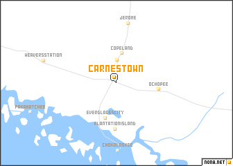
Carnestown (Florida, United States - USA)Carnestown is a town in the Florida region of United States - USA. An overview map of the region around Carnestown is displayed below.
regional and 3d topo map of Carnestown, United States - USA ::
Carnestown airports ::
The nearest airport is RSW - Fort Myers Southwest Florida Intl, located 79.6 km north west of Carnestown.
Other airports nearby include MIA - Miami Intl (108.4 km east), HST - Homestead Arb (109.0 km south east), FLL - Fort Lauderdale Hollywood Intl (122.6 km east), NQX - Key West Nas (151.4 km south), Nearby towns ::
Lee Cypress (3.7km north) //
Copeland (4.8km north) //
Everglades City (5.9km south) //
Ochopee (6.2km east) //
Plantation Island (7.4km south) //
[all distances 'as the bird flies' and approximate]  Places with similar names to Carnestown, United States - USA ::
// Grünstein (DE)
// Kirnstein (DE)
// Cranston (US)
// Greenstone (NZ)
// Cranston (US)
// Cranston (US)
// Kernstown (US)
// Greenstown (US)
// Grensten (DK)
// Grönnäsudden (SE)
Disclaimer :: Information on this page comes without warranty of any kind |
||
|
Where is Carnestown? Elevation and coordinates ::
Latitude (lat): 25°54'38"N Longitude (lon): 81°21'52"W
Elevation (approx.): 2m (map arrows pan, magnifying glasses zoom) |
||
|
Visiting Carnestown? Hotel/Accommodation ::
Book a hotel in Carnestown Travel Guide ::
rental cars ::
car rental offers GPS waypoint ::
download a GPX waypoint (PoI) of Carnestown for your GPS receiver
|
||