|
search place name
|
||
Highland City (Florida, United States - USA)Highland City is a town in the Florida region of United States - USA. An overview map of the region around Highland City is displayed below.
regional and 3d topo map of Highland City, United States - USA ::

Highland City airports ::
The nearest airport is TPA - Tampa Intl, located 64.5 km west of Highland City.
Other airports nearby include MCF - Tampa Macdill Afb (64.6 km west), MCO - Orlando Intl (76.0 km north east), PIE - St. Petersburg St Petersburg Clearwater Intl (79.9 km west), MLB - Melbourne Intl (122.2 km east), Nearby towns ::
Eaton Park (5.6km north west) //
Lyle Corner (5.9km south) //
Lakeland Highlands (7.1km west) //
Crystal Lake (8.4km north) //
Bartow (8.4km south east) //
Gordonville (7.9km east) //
Carters Corner (9.0km north) //
Ridgewood (8.9km south west) //
Fountain Heights (8.3km west) //
Kossuthville (9.3km north) //
Ewell (9.2km south west) //
Jones Corner (9.8km north east) //
Royster (10.8km south west) //
Lakeland (10.9km north west) //
[all distances 'as the bird flies' and approximate] 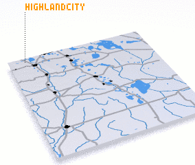 Places with similar names to Highland City, United States - USA ::
// Highland City (US)
Disclaimer :: Information on this page comes without warranty of any kind |
||
|
Where is Highland City? Elevation and coordinates ::
Latitude (lat): 27°57'54"N Longitude (lon): 81°52'41"W
Elevation (approx.): 39m (map arrows pan, magnifying glasses zoom) |
||
|
Visiting Highland City? Hotel/Accommodation ::
Book a hotel in Highland City Travel Guide ::
rental cars ::
car rental offers GPS waypoint ::
download a GPX waypoint (PoI) of Highland City for your GPS receiver
|
||