|
search place name
|
||
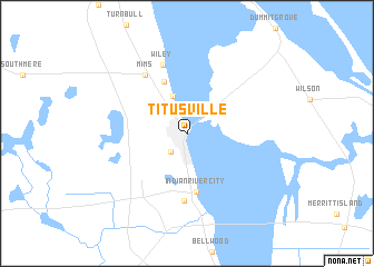
Titusville (Florida, United States - USA)Titusville is a town in the Florida region of United States - USA. An overview map of the region around Titusville is displayed below.
regional and 3d topo map of Titusville, United States - USA ::
Titusville airports ::
The nearest airport is COF - Coco Beach Patrick Afb, located 46.1 km south east of Titusville.
Other airports nearby include MCO - Orlando Intl (53.1 km west), MLB - Melbourne Intl (58.6 km south), VRB - Vero Beach Muni (112.7 km south), TPA - Tampa Intl (183.4 km west), Nearby towns ::
Whispering Hills Golf Estates (2.4km south west) //
La Grange (3.5km north west) //
Jay Jay (3.9km north) //
East Mims (5.6km north) //
Indian River City (5.9km south) //
South Titusville (6.8km south) //
Mims (6.9km north west) //
Wiley (7.2km north) //
[all distances 'as the bird flies' and approximate] 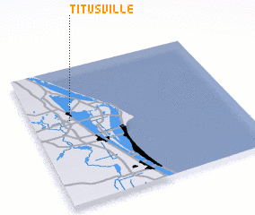 Places with similar names to Titusville, United States - USA ::
// Deatsville (US)
// Doddsville (US)
// Deedsville (US)
// Deatsville (US)
// Doddsville (US)
// Taitsville (US)
// Titusville (US)
// Titusville (US)
// Toddsville (US)
// Tatesville (US)
Disclaimer :: Information on this page comes without warranty of any kind |
||
|
Where is Titusville? Elevation and coordinates ::
Latitude (lat): 28°36'43"N Longitude (lon): 80°48'28"W
Elevation (approx.): 10m (map arrows pan, magnifying glasses zoom) |
||
|
Visiting Titusville? Hotel/Accommodation ::
Book a hotel in Titusville Travel Guide ::
rental cars ::
car rental offers GPS waypoint ::
download a GPX waypoint (PoI) of Titusville for your GPS receiver
|
||