|
search place name
|
||
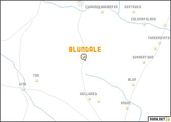
Blundale (Georgia, United States - USA)Blundale is a town in the Georgia region of United States - USA. An overview map of the region around Blundale is displayed below.
regional and 3d topo map of Blundale, United States - USA ::
Blundale airports ::
The nearest airport is AGS - Bush Field Augusta Rgnl At Bush Fld, located 79.7 km north east of Blundale.
Other airports nearby include WRB - Macon Robins Afb (113.2 km west), MCN - Macon Middle Georgia Rgnl (118.1 km west), SAV - Savannah Hilton Head Intl (131.3 km south east), SVN - Hunter Aaf (143.0 km south east), Nearby towns ::
Dellwood (8.4km south) //
Old Dellwood (9.2km south) //
[all distances 'as the bird flies' and approximate]  Places with similar names to Blundale, United States - USA ::
// Buluntalay (RU)
// Bolindale (US)
// Bilundule (CD)
// Balin Dol (MK)
// Buluntuli (MK)
// Balindala (GN)
// Balinndala (ML)
// Bilantal (ML)
// Ballendella (AU)
// Blondel (DZ)
Disclaimer :: Information on this page comes without warranty of any kind |
||
|
Where is Blundale? Elevation and coordinates ::
Latitude (lat): 32°44'53"N Longitude (lon): 82°23'29"W
Elevation (approx.): 117m (map arrows pan, magnifying glasses zoom) |
||
|
Visiting Blundale? Hotel/Accommodation ::
Book a hotel in Blundale Travel Guide ::
rental cars ::
car rental offers GPS waypoint ::
download a GPX waypoint (PoI) of Blundale for your GPS receiver
|
||