|
search place name
|
||
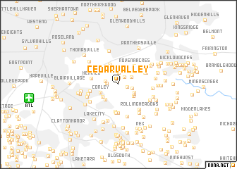
Cedar Valley (Georgia, United States - USA)Cedar Valley is a town in the Georgia region of United States - USA. An overview map of the region around Cedar Valley is displayed below.
regional and 3d topo map of Cedar Valley, United States - USA ::
Cedar Valley airports ::
The nearest airport is ATL - Hartsfield Jackson Atlanta Intl, located 12.0 km west of Cedar Valley.
Other airports nearby include MGE - Marietta Dobbins Arb (Atlanta Nas) (35.0 km north west), MCN - Macon Middle Georgia Rgnl (122.9 km south east), WRB - Macon Robins Afb (130.6 km south east), ANB - Anniston Metro (144.7 km west), Nearby towns ::
Cedar Grove (0.5km north) //
Blue Creek (1.1km north) //
Miramar (1.2km east) //
Wishing Well Hills (1.4km north east) //
Cedar Grove Acres (1.5km west) //
Blue Creek Forest (1.8km north) //
Cherokee Forest (1.8km west) //
Woodcrest (1.9km east) //
Tolliver Heights (2.1km north east) //
Skyline Forest (2.4km north) //
Weather Wood (2.4km north) //
River Hills (2.7km north east) //
Palisades Estates (2.5km south east) //
Country Pine Estates (2.6km south east) //
Ash Manor (2.7km south east) //
Conley (2.6km south west) //
Hyde Park Mobile Home Park (2.9km south west) //
Rocklane Estates (2.9km south west) //
Whitehall Forest Estates (3.4km north) //
Rovena Acres (3.6km north east) //
Forest Ridge (3.7km north east) //
Burkshire (4.4km south) //
Henrico (3.7km west) //
Fernwood (4.5km south) //
Conley Downs (3.9km north east) //
Ellenwood Homes (4.6km south) //
Pleasant Acres (3.9km west) //
Riverside Station (4.1km north east) //
Elizabeth Park (4.3km west) //
[all distances 'as the bird flies' and approximate]  Places with similar names to Cedar Valley, United States - USA ::
// Cedarville (US)
// Star Valley (US)
// Cedarville (US)
// Seedörfl (AT)
// Cedarville (US)
// Cedar Valley (US)
// Strevell (US)
// Cedarville (US)
// Cedar Valley (US)
// Cedar Vale (US)
Disclaimer :: Information on this page comes without warranty of any kind |
||
|
Where is Cedar Valley? Elevation and coordinates ::
Latitude (lat): 33°39'21"N Longitude (lon): 84°18'2"W
Elevation (approx.): 255m (map arrows pan, magnifying glasses zoom) |
||
|
Visiting Cedar Valley? Hotel/Accommodation ::
Book a hotel in Cedar Valley Travel Guide ::
rental cars ::
car rental offers GPS waypoint ::
download a GPX waypoint (PoI) of Cedar Valley for your GPS receiver
|
||