|
search place name
|
||
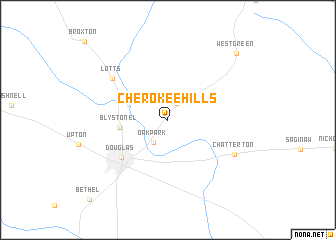
Cherokee Hills (Georgia, United States - USA)Cherokee Hills is a town in the Georgia region of United States - USA. An overview map of the region around Cherokee Hills is displayed below.
regional and 3d topo map of Cherokee Hills, United States - USA ::
Cherokee Hills airports ::
The nearest airport is VAD - Valdosta Moody Afb, located 74.1 km south west of Cherokee Hills.
Other airports nearby include WRB - Macon Robins Afb (142.4 km north west), MCN - Macon Middle Georgia Rgnl (150.2 km north west), JAX - Jacksonville Intl (157.9 km south east), SAV - Savannah Hilton Head Intl (164.7 km north east), Nearby towns ::
Huffer (2.1km north east) //
Oak Park (2.9km south west) //
Blystonel (4.7km west) //
Douglas (6.1km south west) //
Lotts (7.0km north west) //
Chatterton (7.4km south east) //
West Green (9.9km north east) //
Bethel (11.6km south west) //
[all distances 'as the bird flies' and approximate] 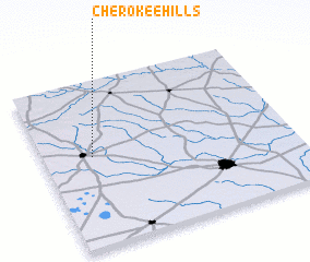 Places with similar names to Cherokee Hills, United States - USA ::
// Cherokee Hills (US)
// Cherokee Hills (US)
// Cherokee Hills (US)
// Cherokee Hills (US)
// Cherokee Hills (US)
// Cherokee Hills (US)
// Cherokee Hills (US)
Disclaimer :: Information on this page comes without warranty of any kind |
||
|
Where is Cherokee Hills? Elevation and coordinates ::
Latitude (lat): 31°32'45"N Longitude (lon): 82°48'11"W
Elevation (approx.): 76m (map arrows pan, magnifying glasses zoom) |
||
|
Visiting Cherokee Hills? Hotel/Accommodation ::
Book a hotel in Cherokee Hills Travel Guide ::
rental cars ::
car rental offers GPS waypoint ::
download a GPX waypoint (PoI) of Cherokee Hills for your GPS receiver
|
||