|
search place name
|
||
Creek Indian (Georgia, United States - USA)Creek Indian is a town in the Georgia region of United States - USA. An overview map of the region around Creek Indian is displayed below.
regional and 3d topo map of Creek Indian, United States - USA ::

Creek Indian airports ::
The nearest airport is ATL - Hartsfield Jackson Atlanta Intl, located 24.8 km east of Creek Indian.
Other airports nearby include MGE - Marietta Dobbins Arb (Atlanta Nas) (32.9 km north east), ANB - Anniston Metro (108.3 km west), MCN - Macon Middle Georgia Rgnl (144.8 km south east), LSF - Fort Benning Lawson Aaf (149.1 km south), Nearby towns ::
Campbellton (2.5km east) //
Cedar Grove (3.6km south) //
Douglas Estates (3.2km north west) //
Rebel Trail (3.8km north) //
Doublegate (3.7km north) //
Chapel Hill (3.7km north west) //
Five Notch Acres (3.7km west) //
The Meadows North (4.9km north) //
Anneewakee (4.3km north west) //
Hilderbrand (4.6km north east) //
Shelby Forest (5.4km north west) //
Holland Manor (5.6km north west) //
Carmel Farms (6.2km north) //
Glen Villa (6.2km north) //
Carmel Chase (6.4km north) //
Springhill Estates (6.6km north) //
Rivertown (6.2km south west) //
Reynolds Estates (6.3km north west) //
Ivey Estates (6.4km north west) //
Anneewakee Estates (6.6km north east) //
Dogwood Acres (7.0km north) //
Corn Creek Cove (6.3km south east) //
Del Ridge (7.5km north) //
Warren Heights (7.8km north) //
Longview Estates (7.6km north west) //
Blair Heights (7.9km north) //
Flowers Estates (7.8km north) //
Tara Woods (8.0km north) //
Stewart Woods (7.4km north west) //
[all distances 'as the bird flies' and approximate] 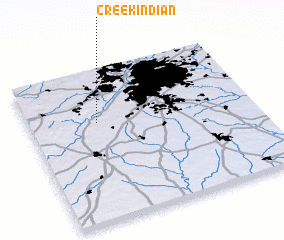 Places with similar names to Creek Indian, United States - USA ::
Disclaimer :: Information on this page comes without warranty of any kind |
||
|
Where is Creek Indian? Elevation and coordinates ::
Latitude (lat): 33°39'30"N Longitude (lon): 84°41'40"W
Elevation (approx.): 251m (map arrows pan, magnifying glasses zoom) |
||
|
Visiting Creek Indian? Hotel/Accommodation ::
Book a hotel in Creek Indian Travel Guide ::
rental cars ::
car rental offers GPS waypoint ::
download a GPX waypoint (PoI) of Creek Indian for your GPS receiver
|
||