|
search place name
|
||
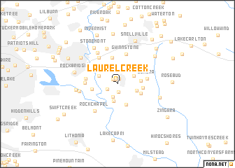
Laurel Creek (Georgia, United States - USA)Laurel Creek is a town in the Georgia region of United States - USA. An overview map of the region around Laurel Creek is displayed below.
regional and 3d topo map of Laurel Creek, United States - USA ::
Laurel Creek airports ::
The nearest airport is ATL - Hartsfield Jackson Atlanta Intl, located 39.6 km south west of Laurel Creek.
Other airports nearby include MGE - Marietta Dobbins Arb (Atlanta Nas) (45.5 km west), MCN - Macon Middle Georgia Rgnl (127.8 km south), WRB - Macon Robins Afb (135.0 km south), AND - Andersen Anderson Rgnl (145.6 km north east), Nearby towns ::
Mason Woods (0.8km north) //
Centerville (0.9km north) //
Monterey Acres (1.0km north west) //
Brandington Forest (1.3km south) //
Mountain Cove (1.6km south west) //
Smoke Creek Mobile Home Park (2.2km south) //
Rock Bridge (2.8km south) //
Twin Village (2.8km north east) //
Quinn Ridge (2.9km north) //
Lochwolde (2.5km north east) //
The Moorings (2.7km north west) //
Innsbrook West (2.8km south east) //
Norris Lake Shores (3.5km south) //
Summer Place (3.2km east) //
Caleb (3.4km south east) //
Innsbrook (3.5km east) //
Meadow Hills (3.5km west) //
Timber Trace (4.2km north) //
Shiloh Farms (4.3km north west) //
Lenora (4.0km east) //
Gwinnstone (4.9km north) //
Cumberland Forest (4.8km north west) //
Castlewood Mobile Home Park (4.3km west) //
The Landings (4.3km west) //
Rock Chapel (5.2km south west) //
Rainbow Estates (5.8km north) //
Scenic Mountain (5.7km north west) //
Bermuda (5.2km west) //
Arbor Ridge (5.6km west) //
[all distances 'as the bird flies' and approximate]  Places with similar names to Laurel Creek, United States - USA ::
// Laurel Creek (US)
// Laurel Creek (US)
// Laurel Creek (US)
// Laurel Creek (US)
// Laurel Creek (US)
Disclaimer :: Information on this page comes without warranty of any kind |
||
|
Where is Laurel Creek? Elevation and coordinates ::
Latitude (lat): 33°47'45"N Longitude (lon): 84°2'45"W
Elevation (approx.): 271m (map arrows pan, magnifying glasses zoom) |
||
|
Visiting Laurel Creek? Hotel/Accommodation ::
Book a hotel in Laurel Creek Travel Guide ::
rental cars ::
car rental offers GPS waypoint ::
download a GPX waypoint (PoI) of Laurel Creek for your GPS receiver
|
||