|
search place name
|
||
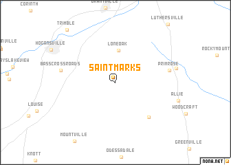
Saint Marks (Georgia, United States - USA)Saint Marks is a town in the Georgia region of United States - USA. An overview map of the region around Saint Marks is displayed below.
regional and 3d topo map of Saint Marks, United States - USA ::
Saint Marks airports ::
The nearest airport is ATL - Hartsfield Jackson Atlanta Intl, located 67.5 km north east of Saint Marks.
Other airports nearby include LSF - Fort Benning Lawson Aaf (88.8 km south), MGE - Marietta Dobbins Arb (Atlanta Nas) (92.1 km north), ANB - Anniston Metro (109.3 km north west), MCN - Macon Middle Georgia Rgnl (119.7 km south east), Nearby towns ::
Lone Oak (5.2km north) //
Thompson Crossroad (7.2km south east) //
Primrose (7.6km east) //
Trimble (10.8km north west) //
[all distances 'as the bird flies' and approximate] 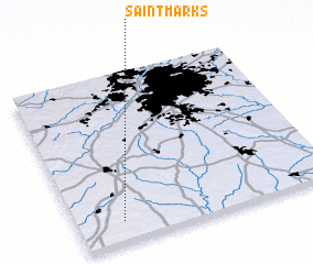 Places with similar names to Saint Marks, United States - USA ::
// Saint Marks (US)
// Saint Marks (US)
// Saint Marks (US)
// Saint Marks (BB)
// Saint Markʼs (ZA)
// Saint-Ambroix (FR)
// Saint-Ambroix (FR)
Disclaimer :: Information on this page comes without warranty of any kind |
||
|
Where is Saint Marks? Elevation and coordinates ::
Latitude (lat): 33°7'31"N Longitude (lon): 84°49'16"W
Elevation (approx.): 270m (map arrows pan, magnifying glasses zoom) |
||
|
Visiting Saint Marks? Hotel/Accommodation ::
Book a hotel in Saint Marks Travel Guide ::
rental cars ::
car rental offers GPS waypoint ::
download a GPX waypoint (PoI) of Saint Marks for your GPS receiver
|
||