|
search place name
|
||
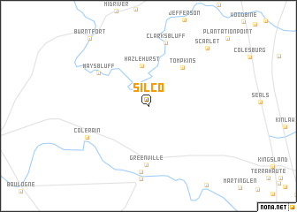
Silco (Georgia, United States - USA)Silco is a town in the Georgia region of United States - USA. An overview map of the region around Silco is displayed below.
regional and 3d topo map of Silco, United States - USA ::
Silco airports ::
The nearest airport is JAX - Jacksonville Intl, located 43.7 km south of Silco.
Other airports nearby include NIP - Jacksonville Nas (71.6 km south), VAD - Valdosta Moody Afb (130.6 km west), GNV - Gainesville Rgnl (137.3 km south), SVN - Hunter Aaf (142.4 km north east), Nearby towns ::
Bullhead Bluff (2.4km north west) //
Hazlehurst (5.1km north) //
Tompkins (6.0km north east) //
Greenville (7.4km south) //
Mays Bluff (6.8km north west) //
Clarks Bluff (8.2km north) //
Flea Hill (8.4km south) //
Colerain (7.7km south west) //
Scarlet (9.7km north east) //
Burnt Fort (10.7km north west) //
[all distances 'as the bird flies' and approximate] 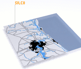 Places with similar names to Silco, United States - USA ::
Disclaimer :: Information on this page comes without warranty of any kind |
||
|
Where is Silco? Elevation and coordinates ::
Latitude (lat): 30°52'5"N Longitude (lon): 81°49'52"W
Elevation (approx.): 11m (map arrows pan, magnifying glasses zoom) |
||
|
Visiting Silco? Hotel/Accommodation ::
Book a hotel in Silco Travel Guide ::
rental cars ::
car rental offers GPS waypoint ::
download a GPX waypoint (PoI) of Silco for your GPS receiver
|
||