|
search place name
|
||
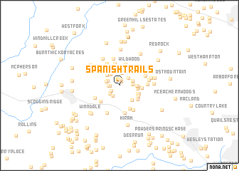
Spanish Trails (Georgia, United States - USA)Spanish Trails is a town in the Georgia region of United States - USA. An overview map of the region around Spanish Trails is displayed below.
regional and 3d topo map of Spanish Trails, United States - USA ::
Spanish Trails airports ::
The nearest airport is MGE - Marietta Dobbins Arb (Atlanta Nas), located 23.9 km east of Spanish Trails.
Other airports nearby include ATL - Hartsfield Jackson Atlanta Intl (45.7 km south east), ANB - Anniston Metro (107.4 km west), CHA - Chattanooga Lovell Fld (128.7 km north), MCN - Macon Middle Georgia Rgnl (172.7 km south east), Nearby towns ::
Keener Estates (0.6km north) //
Tabor Estates (1.0km north) //
Indian Springs (1.2km west) //
Denton Manor (1.4km south west) //
Oak Dale Manor (1.5km west) //
Hidden Oaks (1.7km north east) //
Wilbanks Circle (1.8km south west) //
Musket Ridge (1.7km north west) //
Twelve Oaks (2.0km north) //
Brock (1.8km south west) //
Brooks Estates (1.7km east) //
Rock Falls Estates (1.8km west) //
Lost Meadows (1.8km east) //
Cross Creek (2.1km north west) //
White Forest (2.3km north west) //
Southfork (2.3km east) //
Gold Creek (2.4km east) //
Hardy Hills (2.5km east) //
Macland Springs (2.8km south east) //
Creekwood Estates (2.7km south east) //
Country Acres (3.1km north west) //
California (2.9km south east) //
Gunnell Place (3.4km north) //
Powder Creek Crossing (3.0km south east) //
Wildwood (3.3km north east) //
Forest Creek Colony (3.5km north) //
New Hope (3.4km north west) //
Hearthwood (3.2km south east) //
Timberchase (2.9km east) //
[all distances 'as the bird flies' and approximate]  Places with similar names to Spanish Trails, United States - USA ::
// Spanish Trails (US)
Disclaimer :: Information on this page comes without warranty of any kind |
||
|
Where is Spanish Trails? Elevation and coordinates ::
Latitude (lat): 33°55'51"N Longitude (lon): 84°46'26"W
Elevation (approx.): 360m (map arrows pan, magnifying glasses zoom) |
||
|
Visiting Spanish Trails? Hotel/Accommodation ::
Book a hotel in Spanish Trails Travel Guide ::
rental cars ::
car rental offers GPS waypoint ::
download a GPX waypoint (PoI) of Spanish Trails for your GPS receiver
|
||