|
search place name
|
||
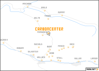
Carbon Center (Idaho, United States - USA)Carbon Center is a town in the Idaho region of United States - USA. An overview map of the region around Carbon Center is displayed below.
regional and 3d topo map of Carbon Center, United States - USA ::
Carbon Center airports ::
The nearest airport is SFF - Spokane Felts Fld, located 107.8 km west of Carbon Center.
Other airports nearby include GEG - Spokane Intl (123.1 km west), SKA - Spokane Fairchild Afb (132.2 km west), YCG - Castlegar (231.9 km north west), Nearby towns ::
Ferguson (1.8km west) //
Bunn (5.3km south) //
Blackcloud (6.0km south) //
Nuckols (5.2km south west) //
Thiard (6.4km north) //
Gem (6.1km south east) //
Frisco (6.0km south east) //
Delta (6.3km north west) //
Black Bear (5.9km south east) //
McCarthy (7.3km south) //
Webb (7.8km south) //
Woodland Park (8.0km south) //
Cornwall (6.5km south east) //
Murray (8.3km north east) //
Silverton (8.3km south west) //
Mace (7.4km south east) //
[all distances 'as the bird flies' and approximate]  Places with similar names to Carbon Center, United States - USA ::
// Carbon Center (US)
// Carbon Center (US)
Disclaimer :: Information on this page comes without warranty of any kind |
||
|
Where is Carbon Center? Elevation and coordinates ::
Latitude (lat): 47°33'30"N Longitude (lon): 115°54'0"W
Elevation (approx.): 903m (map arrows pan, magnifying glasses zoom) |
||
|
Visiting Carbon Center? Hotel/Accommodation ::
Book a hotel in Carbon Center Travel Guide ::
rental cars ::
car rental offers GPS waypoint ::
download a GPX waypoint (PoI) of Carbon Center for your GPS receiver
|
||