|
search place name
|
||
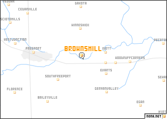
Browns Mill (Illinois, United States - USA)Browns Mill is a town in the Illinois region of United States - USA. An overview map of the region around Browns Mill is displayed below.
regional and 3d topo map of Browns Mill, United States - USA ::
Browns Mill airports ::
The nearest airport is MSN - Madison Dane Co Rgnl Truax Fld, located 96.4 km north of Browns Mill.
Other airports nearby include ORD - Chicago Ohare Intl (137.8 km east), MKE - Milwaukee General Mitchell Intl (152.4 km north east), MDW - Chicago Midway Intl (156.5 km east), IKK - Greater Kankakee (193.7 km south east), Nearby towns ::
Ridott Corners (3.8km east) //
Ridott (4.1km north east) //
Evarts (5.0km south east) //
Winneshiek (6.9km north) //
Hunt Corners (5.4km east) //
South Freeport (6.3km south west) //
German Valley (8.4km south east) //
[all distances 'as the bird flies' and approximate] 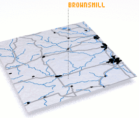 Places with similar names to Browns Mill, United States - USA ::
// Byrnes Mill (US)
// Browns Mill (US)
// Burns Mill (US)
// Browns Mill (US)
// Browns Mill (US)
// Browns Mill (US)
// Barnes Mill (US)
// Browns Mill (US)
// Brunsmåla (SE)
// Birinci Milli (AZ)
Disclaimer :: Information on this page comes without warranty of any kind |
||
|
Where is Browns Mill? Elevation and coordinates ::
Latitude (lat): 42°16'56"N Longitude (lon): 89°31'15"W
Elevation (approx.): 234m (map arrows pan, magnifying glasses zoom) |
||
|
Visiting Browns Mill? Hotel/Accommodation ::
Book a hotel in Browns Mill Travel Guide ::
rental cars ::
car rental offers GPS waypoint ::
download a GPX waypoint (PoI) of Browns Mill for your GPS receiver
|
||