|
search place name
|
||
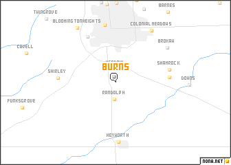
Burns (Illinois, United States - USA)Burns is a town in the Illinois region of United States - USA. An overview map of the region around Burns is displayed below.
regional and 3d topo map of Burns, United States - USA ::
Burns airports ::
The nearest airport is IKK - Greater Kankakee, located 121.2 km north east of Burns.
Other airports nearby include HUF - Terre Haute Intl Hulman Fld (177.5 km south east), MDW - Chicago Midway Intl (185.2 km north east), ORD - Chicago Ohare Intl (197.1 km north east), BLV - Belleville Scott Afb Midamerica (218.8 km south), Nearby towns ::
Hendrix (2.1km north) //
Randolph (2.7km south) //
Willow Creek Trailer Park (8.2km north west) //
Gillum (6.7km east) //
Shamrock (7.0km east) //
Brokaw (8.6km north east) //
Colonial Meadows (9.6km north east) //
[all distances 'as the bird flies' and approximate] 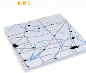 Places with similar names to Burns, United States - USA ::
Disclaimer :: Information on this page comes without warranty of any kind |
||
|
Where is Burns? Elevation and coordinates ::
Latitude (lat): 40°24'1"N Longitude (lon): 88°58'42"W
Elevation (approx.): 247m (map arrows pan, magnifying glasses zoom) |
||
|
Visiting Burns? Hotel/Accommodation ::
Book a hotel in Burns Travel Guide ::
rental cars ::
car rental offers GPS waypoint ::
download a GPX waypoint (PoI) of Burns for your GPS receiver
|
||