|
search place name
|
||
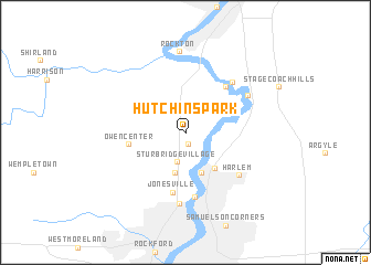
Hutchins Park (Illinois, United States - USA)Hutchins Park is a town in the Illinois region of United States - USA. An overview map of the region around Hutchins Park is displayed below.
regional and 3d topo map of Hutchins Park, United States - USA ::
Hutchins Park airports ::
The nearest airport is MSN - Madison Dane Co Rgnl Truax Fld, located 87.4 km north of Hutchins Park.
Other airports nearby include ORD - Chicago Ohare Intl (105.7 km south east), MKE - Milwaukee General Mitchell Intl (114.7 km north east), MDW - Chicago Midway Intl (127.1 km south east), IKK - Greater Kankakee (177.2 km south east), Nearby towns ::
Latham Park (1.3km south) //
Sturbridge Village (3.1km south) //
Genet (4.2km south) //
North Park (4.2km south) //
Machesney Park (4.2km south east) //
Owen Center (4.4km west) //
Riverdale (5.4km north east) //
Jonesville (6.1km south) //
Loves Park (6.6km south) //
Morehaven (6.1km north east) //
Harlem (5.9km south east) //
Ruby (7.1km south) //
Roscoe (6.0km north east) //
Rockton (8.1km north) //
[all distances 'as the bird flies' and approximate]  Places with similar names to Hutchins Park, United States - USA :: Disclaimer :: Information on this page comes without warranty of any kind |
||
|
Where is Hutchins Park? Elevation and coordinates ::
Latitude (lat): 42°22'46"N Longitude (lon): 89°3'57"W
Elevation (approx.): 228m (map arrows pan, magnifying glasses zoom) |
||
|
Visiting Hutchins Park? Hotel/Accommodation ::
Book a hotel in Hutchins Park Travel Guide ::
rental cars ::
car rental offers GPS waypoint ::
download a GPX waypoint (PoI) of Hutchins Park for your GPS receiver
|
||