|
search place name
|
||
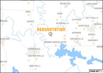
Reeds Station (Illinois, United States - USA)Reeds Station is a town in the Illinois region of United States - USA. An overview map of the region around Reeds Station is displayed below.
regional and 3d topo map of Reeds Station, United States - USA ::
Reeds Station airports ::
The nearest airport is BLV - Belleville Scott Afb Midamerica, located 103.7 km north west of Reeds Station.
Other airports nearby include STL - St. Louis Lambert St Louis Intl (151.0 km north west), HOP - Hopkinsville Campbell Aaf (192.3 km south east), BYH - Blytheville Arkansas Intl (213.0 km south), HUF - Terre Haute Intl Hulman Fld (246.1 km north east), Nearby towns ::
Crab Orchard Estates (3.4km south) //
Cambria (3.7km east) //
Fredonia (3.7km east) //
Blairsville (4.9km north east) //
Hurst (6.3km north) //
Bush (7.7km north) //
Carbondale (7.5km south west) //
De Soto (7.4km north west) //
Southern Hills (9.3km south west) //
Ward (10.4km north west) //
Evergreen Terrace (10.9km south west) //
[all distances 'as the bird flies' and approximate]  Places with similar names to Reeds Station, United States - USA ::
// Reed Station (US)
Disclaimer :: Information on this page comes without warranty of any kind |
||
|
Where is Reeds Station? Elevation and coordinates ::
Latitude (lat): 37°46'40"N Longitude (lon): 89°9'39"W
Elevation (approx.): 126m (map arrows pan, magnifying glasses zoom) |
||
|
Visiting Reeds Station? Hotel/Accommodation ::
Book a hotel in Reeds Station Travel Guide ::
rental cars ::
car rental offers GPS waypoint ::
download a GPX waypoint (PoI) of Reeds Station for your GPS receiver
|
||