|
search place name
|
||
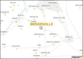
Bargersville (Indiana, United States - USA)Bargersville is a town in the Indiana region of United States - USA. An overview map of the region around Bargersville is displayed below.
regional and 3d topo map of Bargersville, United States - USA ::
Bargersville airports ::
The nearest airport is IND - Indianapolis Intl, located 24.4 km north west of Bargersville.
Other airports nearby include HUF - Terre Haute Intl Hulman Fld (98.4 km west), GUS - Peru Grissom Arb (125.2 km north), CVG - Cincinnati Northern Kentucky Intl (139.6 km east), LOU - Louisville Bowman Fld (150.0 km south), Nearby towns ::
Old Bargersville (1.1km east) //
Providence (3.4km south) //
Kinder (3.6km north west) //
Waterloo (5.3km north west) //
Stones Crossing (6.4km north) //
Hopewell (5.4km south east) //
Bluff Creek (6.1km north west) //
El Dorado (7.8km north) //
Bud (8.2km south) //
Mount Pleasant (7.9km south east) //
Critchfield (8.8km north) //
New Whiteland (7.5km north east) //
[all distances 'as the bird flies' and approximate]  Places with similar names to Bargersville, United States - USA ::
// Bridgersville (US)
Disclaimer :: Information on this page comes without warranty of any kind |
||
|
Where is Bargersville? Elevation and coordinates ::
Latitude (lat): 39°31'15"N Longitude (lon): 86°10'4"W
Elevation (approx.): 249m (map arrows pan, magnifying glasses zoom) |
||
|
Visiting Bargersville? Hotel/Accommodation ::
Book a hotel in Bargersville Travel Guide ::
rental cars ::
car rental offers GPS waypoint ::
download a GPX waypoint (PoI) of Bargersville for your GPS receiver
|
||