|
search place name
|
||
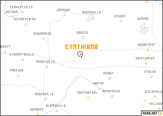
Cynthiana (Indiana, United States - USA)Cynthiana is a town in the Indiana region of United States - USA. An overview map of the region around Cynthiana is displayed below.
regional and 3d topo map of Cynthiana, United States - USA ::
Cynthiana airports ::
The nearest airport is HUF - Terre Haute Intl Hulman Fld, located 144.6 km north of Cynthiana.
Other airports nearby include FTK - Fort Knox Godman Aaf (155.7 km east), HOP - Hopkinsville Campbell Aaf (169.6 km south), IND - Indianapolis Intl (209.5 km north east), Nearby towns ::
Mounts (4.8km north) //
Nisbet (6.8km south east) //
Martin (7.7km south east) //
Poseyville (6.7km west) //
Armstrong (10.3km south east) //
[all distances 'as the bird flies' and approximate]  Places with similar names to Cynthiana, United States - USA ::
// Sinthin (MM)
// Cynthiana (US)
// Cynthiana (US)
// Saint-Haon (FR)
// Say Yên Than (VN)
// Sen Thon (VN)
// Sin Than (VN)
// Sơn Thãnh (VN)
// Xuân Thôn (VN)
// Xuân Thành (VN)
Disclaimer :: Information on this page comes without warranty of any kind |
||
|
Where is Cynthiana? Elevation and coordinates ::
Latitude (lat): 38°11'15"N Longitude (lon): 87°42'37"W
Elevation (approx.): 144m (map arrows pan, magnifying glasses zoom) |
||
|
Visiting Cynthiana? Hotel/Accommodation ::
Book a hotel in Cynthiana Travel Guide ::
rental cars ::
car rental offers GPS waypoint ::
download a GPX waypoint (PoI) of Cynthiana for your GPS receiver
|
||