|
search place name
|
||
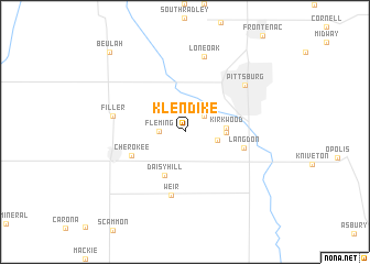
Klendike (Kansas, United States - USA)Klendike is a town in the Kansas region of United States - USA. An overview map of the region around Klendike is displayed below.
regional and 3d topo map of Klendike, United States - USA ::
Klendike airports ::
The nearest airport is FYV - Fayetteville Drake Fld, located 160.1 km south of Klendike.
Other airports nearby include TUL - Tulsa Intl (164.3 km south west), SZL - Knobnoster Whiteman Afb (184.9 km north east), HRO - Harrison Boone Co (188.6 km south east), FOE - Topeka Forbes Fld (192.8 km north west), Nearby towns ::
Chicopee (2.2km north east) //
Fleming (2.1km west) //
Kramer (2.8km east) //
Atlas (3.3km east) //
Kirkwood (3.3km east) //
Daisy Hill (4.7km south) //
Cherokee (5.0km south west) //
Langdon (5.1km east) //
Weir (6.5km south) //
Filler (6.0km west) //
Pittsburg (6.8km north east) //
Lone Oak (7.8km north) //
Beulah (10.1km north west) //
[all distances 'as the bird flies' and approximate] 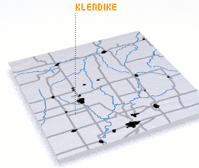 Places with similar names to Klendike, United States - USA ::
// Calantac (PH)
// Calantigao (PH)
// Klondike (US)
// Klondyke (US)
// Klondike (US)
// Klondike (US)
// Klondike (US)
// Klondike (US)
// Kolonie Tieckow (DE)
// Klondike (US)
Disclaimer :: Information on this page comes without warranty of any kind |
||
|
Where is Klendike? Elevation and coordinates ::
Latitude (lat): 37°22'4"N Longitude (lon): 94°45'34"W
Elevation (approx.): 288m (map arrows pan, magnifying glasses zoom) |
||
|
Visiting Klendike? Hotel/Accommodation ::
Book a hotel in Klendike Travel Guide ::
rental cars ::
car rental offers GPS waypoint ::
download a GPX waypoint (PoI) of Klendike for your GPS receiver
|
||