|
search place name
|
||
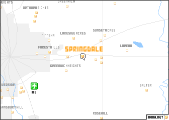
Springdale (Kansas, United States - USA)Springdale is a town in the Kansas region of United States - USA. An overview map of the region around Springdale is displayed below.
regional and 3d topo map of Springdale, United States - USA ::
Springdale airports ::
The nearest airport is IAB - Wichita Mc Connell Afb, located 10.6 km south west of Springdale.
Other airports nearby include ICT - Wichita Mid Continent (23.5 km west), FRI - Fort Riley Marshall Aaf (157.2 km north), END - Enid Vance Afb (162.5 km south west), FOE - Topeka Forbes Fld (193.3 km north east), Nearby towns ::
Park East (1.0km north) //
Mecca Acres (2.0km east) //
Brookhaven (2.6km north east) //
Midway (3.0km east) //
Linwood Acres (3.0km west) //
Lakeview Heights (3.0km east) //
Prairie Village (3.8km north east) //
Greenwich Heights (4.0km south west) //
Lakeside Acres (5.2km north) //
Andover (5.2km north east) //
Sunset Acres (6.6km north east) //
Forest Hills (6.4km west) //
Bonnie Brae (7.0km west) //
Minneha (7.6km north west) //
[all distances 'as the bird flies' and approximate] 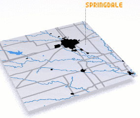 Places with similar names to Springdale, United States - USA ::
// Springdale (US)
// Springdale (US)
// Springdale (US)
// Springdale (US)
// Springdale (US)
// Springdale (US)
// Springdale (US)
// Springdale (US)
// Springdale (US)
// Springdale (US)
Disclaimer :: Information on this page comes without warranty of any kind |
||
|
Where is Springdale? Elevation and coordinates ::
Latitude (lat): 37°40'30"N Longitude (lon): 97°10'7"W
Elevation (approx.): 400m (map arrows pan, magnifying glasses zoom) |
||
|
Visiting Springdale? Hotel/Accommodation ::
Book a hotel in Springdale Travel Guide ::
rental cars ::
car rental offers GPS waypoint ::
download a GPX waypoint (PoI) of Springdale for your GPS receiver
|
||