|
search place name
|
||
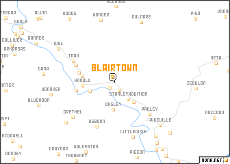
Blair Town (Kentucky, United States - USA)Blair Town is a town in the Kentucky region of United States - USA. An overview map of the region around Blair Town is displayed below.
regional and 3d topo map of Blair Town, United States - USA ::
Blair Town airports ::
The nearest airport is HKY - Hickory Rgnl, located 226.7 km south east of Blair Town.
Other airports nearby include TYS - Knoxville Mc Ghee Tyson (229.7 km south west), LUK - Cincinnati Muni Lunken Fld (236.0 km north west), Nearby towns ::
Broad Bottom (1.1km south west) //
Mossy Bottom (1.5km south) //
Stanley Addition (3.3km south east) //
Boldman (3.6km south west) //
Coal Run Village (4.1km south east) //
Owsley (4.6km south) //
Harold (4.2km west) //
Betsy Layne (4.3km west) //
Justell (4.9km west) //
Amba (5.2km west) //
Stanville (5.7km north west) //
Tram (6.3km north west) //
Pauley (6.9km south east) //
Osborn (7.7km south) //
Grethel (7.9km south west) //
Pikeville (9.2km south east) //
Grethel PO (9.2km south west) //
Titan Siding (10.3km south east) //
[all distances 'as the bird flies' and approximate] 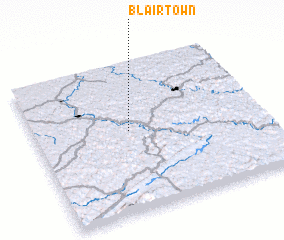 Places with similar names to Blair Town, United States - USA ::
// Beelerton (US)
// Blairtown (US)
// Baylortown (US)
// Bühlertann (DE)
// Blairton (US)
// Blairtown (US)
Disclaimer :: Information on this page comes without warranty of any kind |
||
|
Where is Blair Town? Elevation and coordinates ::
Latitude (lat): 37°32'33"N Longitude (lon): 82°35'9"W
Elevation (approx.): 201m (map arrows pan, magnifying glasses zoom) |
||
|
Visiting Blair Town? Hotel/Accommodation ::
Book a hotel in Blair Town Travel Guide ::
rental cars ::
car rental offers GPS waypoint ::
download a GPX waypoint (PoI) of Blair Town for your GPS receiver
|
||