|
search place name
|
||
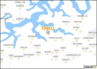
Cabell (Kentucky, United States - USA)Cabell is a town in the Kentucky region of United States - USA. An overview map of the region around Cabell is displayed below.
regional and 3d topo map of Cabell, United States - USA ::
Cabell airports ::
The nearest airport is TYS - Knoxville Mc Ghee Tyson, located 145.2 km south east of Cabell.
Other airports nearby include FTK - Fort Knox Godman Aaf (146.9 km north west), LOU - Louisville Bowman Fld (165.5 km north), BNA - Nashville Intl (169.1 km south west), CHA - Chattanooga Lovell Fld (200.1 km south), Nearby towns ::
Ramsey Island (3.1km south east) //
Murl (4.8km south east) //
Watauga (5.4km west) //
Narvel (6.2km south west) //
Wait (7.2km south) //
Cumberland City (6.2km south west) //
Alpha (7.7km south) //
Zula (7.5km south) //
Parnell (6.8km north east) //
Susie (7.6km south east) //
Nora (8.5km south) //
Cartwright (10.7km south west) //
[all distances 'as the bird flies' and approximate] 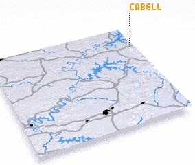 Places with similar names to Cabell, United States - USA ::
Disclaimer :: Information on this page comes without warranty of any kind |
||
|
Where is Cabell? Elevation and coordinates ::
Latitude (lat): 36°49'52"N Longitude (lon): 85°0'25"W
Elevation (approx.): 313m (map arrows pan, magnifying glasses zoom) |
||
|
Visiting Cabell? Hotel/Accommodation ::
Book a hotel in Cabell Travel Guide ::
rental cars ::
car rental offers GPS waypoint ::
download a GPX waypoint (PoI) of Cabell for your GPS receiver
|
||