|
search place name
|
||
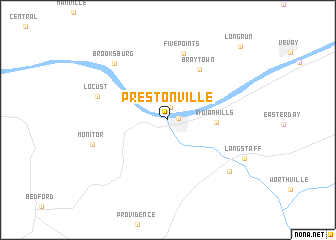
Prestonville (Kentucky, United States - USA)Prestonville is a town in the Kentucky region of United States - USA. An overview map of the region around Prestonville is displayed below.
regional and 3d topo map of Prestonville, United States - USA ::
Prestonville airports ::
The nearest airport is CVG - Cincinnati Northern Kentucky Intl, located 61.1 km north east of Prestonville.
Other airports nearby include LOU - Louisville Bowman Fld (65.0 km south west), LUK - Cincinnati Muni Lunken Fld (81.8 km north east), FTK - Fort Knox Godman Aaf (109.7 km south west), IND - Indianapolis Intl (149.6 km north west), Nearby towns ::
Carrollton (0.9km east) //
Lamb (1.4km north) //
Indian Hills (4.3km east) //
Braytown (6.3km north east) //
Five Points (7.6km north) //
Locust (6.7km north west) //
Brooksburg (7.8km north west) //
Monitor (7.2km south west) //
English (7.9km south east) //
Langstaff (7.9km south east) //
Long Run (10.3km north east) //
[all distances 'as the bird flies' and approximate]  Places with similar names to Prestonville, United States - USA ::
// Prestonville (US)
Disclaimer :: Information on this page comes without warranty of any kind |
||
|
Where is Prestonville? Elevation and coordinates ::
Latitude (lat): 38°40'47"N Longitude (lon): 85°11'25"W
Elevation (approx.): 142m (map arrows pan, magnifying glasses zoom) |
||
|
Visiting Prestonville? Hotel/Accommodation ::
Book a hotel in Prestonville Travel Guide ::
rental cars ::
car rental offers GPS waypoint ::
download a GPX waypoint (PoI) of Prestonville for your GPS receiver
|
||